Last week I hiked along the east side of the river bluffs in a section of the Kickapoo Valley Reserve.
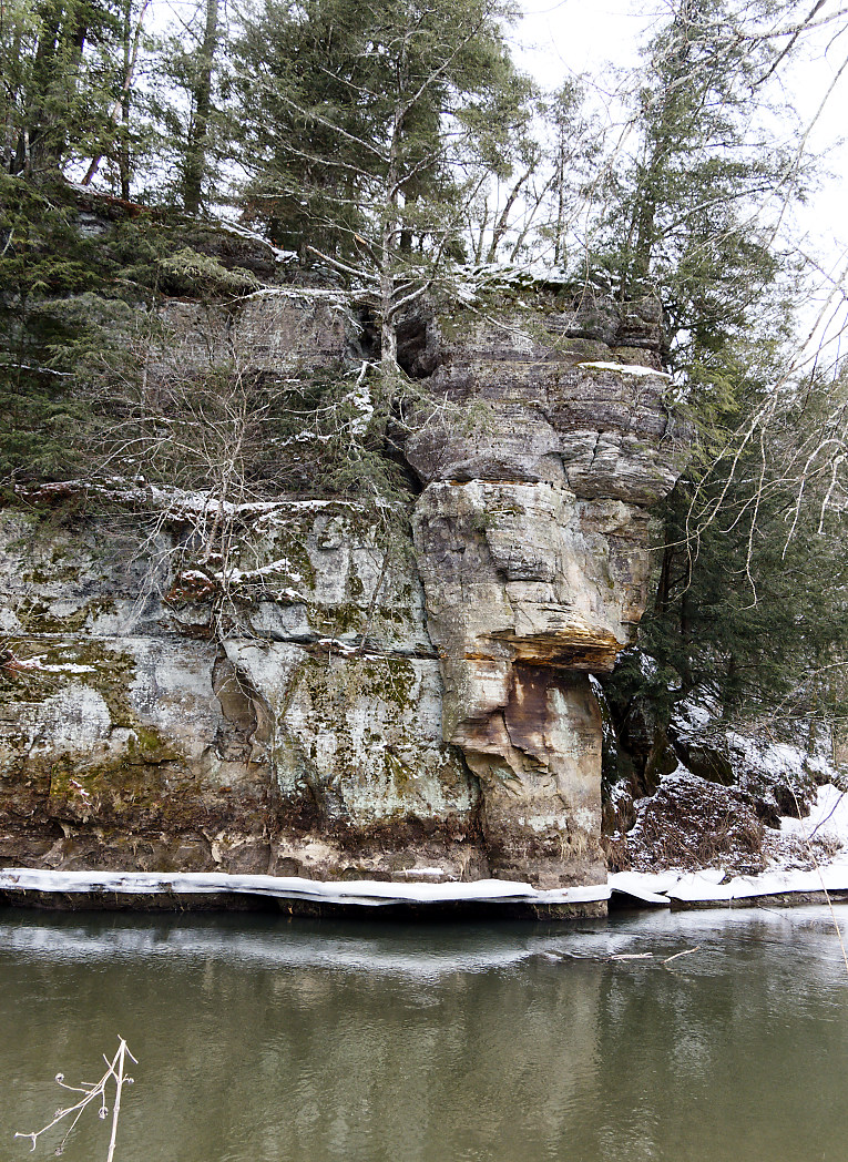
View of last week's hike from the other side
of the river.

I wanted to see just how far down the river I could get before I ran out of shoreline. Charlie and I made it about 3/4 of a mile and it was there that I noticed the large chunk of bluff that had broken away from the original bluff.
Now this could have happened a thousand years ago or whenever. I'm not a geologist, so I haven't a clue.
I wanted to compare it to the term 'calving' like when a large chunk of ice comes off a glacier.
I wanted to compare it to the term 'calving' like when a large chunk of ice comes off a glacier.
I decided to walk along the western bank which has no bluffs, however that is where all the logs, trees, and debris from floods end up.
It is a definite maze of downed trees, logs, roots, and weeds.
I didn't wear snowshoes so I had to fight the deep snow. Wearing the snowshoes would have made the climbing roots and logs much more complicated.
I saw coyote tracks, I saw a beaver in the partially frozen pond to the south, but what really surprised me were some odd tracks on top of the snow.
It looked like something had been sliding in and out of the river.
It looked like something had been sliding in and out of the river.

It finally dawned on me when I saw a hole in the bank with tracks in and out, that perhaps the river had otters?
Oh Boy!
I studied the terrain directly across from the 'den' and thought it would be fun to come back and sit quietly on the bank or bluff above the supposed den and watch.
I've never seen a wild otter.
I did a LOT of climbing over banks and logs. Here is a photo of my leg in the side of an icy bank. [No, I would not have ended up in the river if I'd fallen! I was at least 10 feet from the water. I play it safe when alone.]

Recall the hole in the rock I am searching for? Well last week I stopped at the orange arrow as there was no shore left to walk on.

Another view of the flat rock.
There is the hole, the tunnel, the cave...whatever you want to call it.

Getting there by land is going to involve some research.

The area above the rock bluffs and the river can be hiked but it would be an experience for sure.
Below is a topo map. The orange arrow points to the rock with a hole in it and on each side of that spot, the river is right up against the bluff.
The black triangles are camping spots and the dotted lines are trails. The solid black lines are roads.
The black triangles are camping spots and the dotted lines are trails. The solid black lines are roads.
I may have figured out a way from one of the campsites or come in from the road through the brush and just find my way.

If nothing else, I'll first explore it coming in from the road which would involve less climbing and be able to look out from the top of those bluffs.
The trail next to the river [blue line] is about 160 feet below the top of the bluffs according to their calculations.
This is near that bluff and some straight on shots of the rock formations and ice.
I doubt too many folks see this as it is a chore to get too, but not too bad in the winter time.


My hike ended up being about 4 miles. Half of it was rough hiking and half was on trails. Getting off the trail and walking along the river was really quite beautiful.
I have more bluffs to explore before spring comes....
This looks very adventurous. Are you sure that rock fall isn't recent? As in, could happen again. Proceed with caution, please.
ReplyDeleteIt's been there since at least 1996 when I saw it the first time while riding a mule. It is pretty safe. There are several just like it along this side of the river. I am always careful. Thank you!
DeleteVery scenic shot of the hole in the rock! I am sure you will find a way by land!
ReplyDeleteFun hike! That big 'ol rock is so cool in many ways!!
ReplyDelete