Showing posts with label KVR Trails. Show all posts

Sunday, April 09, 2023

Going Up!


 Map My Hike says this hike had 435 feet of elevation in it. Hmmm. 

I'm not sure how these apps that follow you figure that out. But I do know that from where I parked to the top of the narrow back ridge was a climb of 300 feet. That is according to the topo map from KVR. 
I didn't do a 'close up' of the map because I wanted those read the drivel I write to see what the terrain is like where I walk.

This is the terrain of the 'driftless' region of Wisconsin. The bumps are hills, the shaded parts are slopes. The terrain map helps visualize what it is like where I live. Nothing is level, it is up or down!

The trail is pretty straightforward to the top. 


It is either an old logging road or farm road, it leads to an open area that has been logged and left. Briers and Prickly Ash grow so thick in its place that I doubt anyone or anything would want to walk the open area.


The trail goes around this mess and stays on the sides of the ridge in a mostly old oak forest. Finding the trail in the summer is nearly impossible as Charlie and I found out last year.

We found the top of the ridge easily.


We walked out to the point to see if there was much of a view.

I could look south and see Highway 131 ...


and look north and see the Highway leading to Rockton.


In the summer these limited views are impossible. But, I satisfied my curiosity and decided to finish the trail.


Some places were well marked, and others markers were a spot of yellow ribbon tied to a branch or a tree.

There is no chance of really getting lost as long as you have looked at the map and know to travel around the top of the oddly shaped ridge.
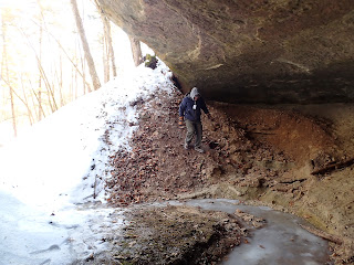
There is a steep drop off  if you do get off the ridge.


It doesn't seem at first that Jug Creek has a lot to offer in the wow factor. However, the old oak stands and maple woods provide a lot of shade and it is nice and cool on a hot summer day on the narrow ridge.
In the spring the forest floor will be covered in Spring Beauties and Pinks.

According to the pamphlet that is available at the Visitors Center, this trail is still under reconstruction. Clearing sections of this trail is not going to be an easy task.

I'd actually like to come back in the winter and snowshoe around the ridge.

Section 44 done.

Monday, October 31, 2022

Section 30 County P ~ KVR Trail Challenge


Recall that little blind? It is so tiny, even a little person like myself can barely move in it. 

However it is proving to be pretty fun on some mornings. This little 8 point buck was about 300 yards away at the other end of the meadow.

This little doe came from the neighbor's meadow and walked between the fence wires. 


She kept looking around and the buck at the other end of our meadow saw/smelled her. He walked towards me and she ducked into the woods just west of this shot.

That was all the action I saw on Friday morning.

Charlie and I loaded up and headed out to tackle the trail section I'd been avoiding at Kickapoo Valley Reserve. 


Charlie and I saw some traffic and a lot of pheasant hunters. Charlie got his fill of hearing shotguns go off near the Weister Creek Trail. He became a bit nervous but didn't freak out. 

In my opinion there is no benefit to having the side of the road be designated as a Trail to hike on. 


The Trail Section is #30. It runs from Pott's Corners to KV Ranch which used to have horses years ago and would take folks on trail rides.  A person could stay at the cabin and ride down the road to access the rest of the KVR Trails.
Part of the access was a gate that led to a short section of the West Ridge Trail that still exists but is poorly maintained. We found the marker on our way back from the end near the KV Ranch. 

It was hidden and had not obviously been used, yet is part of the Trail Challenge.

Once we brush busted through the berry briars we did end up on what used to be a nicely groomed steep uphill climb. When I got to the top of the hogback ridge, the trail disappeared off to the right somewhere. There was no evidence of it being used recently at all. 

We spent time searching and found pieces of the trail. There were no markers, however if one studied the leaves and the ground you could sort of figure out where it was supposed to be.

It was however, very pretty.


We followed the trail and ducked under branches and went around deadfalls until we came out on Strait Rd at County P.


The mileage for this one way was 1.87. We may have done more as we wandered here and there to scout out the trail.

We found an area in the West Ridge Trail [woods] that was loaded with Wild Ginger and Hepatica. I noted that it would be neat to see the abundance of wildflowers next spring.

We made it back to where we parked with no issues. The traffic wasn't too bad on the road, but still it kept me wondering why it was marked as a trail. 


I have one other trail just like this to knock off this week and it is a bit longer. It runs from County F near the Wildcat Mountain border, follows State Hwy 131 for a bit and then heads out Hay Valley Rd to Campsite U and the Hay Valley Trail Head. 
At least part of this trail has a beaten down trail in the grass off of the road on County F.

Having a partner for these trails would be really nice. As it is I am doing them solo with Charlie so we walk the 'trail' and turn around and walk back.
With Bill we'd park one vehicle at each end and walk point to point.

I'm still close to our goal though.

With all the backtracking Charlie and I have done, I figured we've done about 70 miles of hiking or more at the KVR. All of it has been an adventure.

Charlie has been a champ. I think it proves that little short/long dogs can do it too. There have been a few times when I've had to carry him in warmer weather, but mostly he is an avid hiker.

Our goal is within reach and I hope to have it finished off before the gun deer season begins.  I have 4 more planned hikes. Three of them will require me to again go over trails I have done to trails I haven't done and then return.

I'm okay with that as it allows me to see the same woods in different seasons.

Here is Charlie in his home made carseat waiting for a treat and a ride home.


I thought I'd regret not getting another terrier, but he has proven to be an excellent partner in hiking as well as cuddling.

And...we are off again hopefully today!

Monday, October 03, 2022

Tofu, Shrimp of the Woods & Adventure

My nephew, Colin, and his wife Kat arrived Friday evening. 

We took a whirl wind tour of Viroqua, which included coffee at Wonderstate [Formerly, Kickapoo Coffee], the Farmer's Market, and Viroqua Food Co-op for supplies and groceries.

Kat made some amazing gluten free muffins and a bread for us when we returned. After eating some delights, us 'kids' set off the the Kickapoo Valley Reserve. I thought we'd avoid all the hoopla of the Dam Challenge by heading over to Wiester Creek.

We headed up the West Ridge Trail and then went down the hill to Ma & Pa's trail. Yippee! One more section to cross off for me! Section 29 is done!

Infrared photo of the West Ridge Trail


As we headed down Ma & Pa's Trail, we encountered a couple hiking towards us with a full basket of mushrooms.
We were looking for them as well as trying to spot birds either visually or by song.

Mr. and Mrs. Kingfisher watching for birds!
Colin has edible Fungi in the red bandana.


We started to find Shrimp of the Woods


Then we went...

off the map...


And unfortunately, we had to do some major brush busting. However, that led us to even more Shrimp of the Woods!


Our take after cleaning them and before Colin cooked them:


Our last part of the off the map trek took us through a corn field to where we parked.

Charlie led the way. Colin and Kat wanted to see what Charlie looked like in Infrared.

He looked like a Zombie Dog!


PS~ The Shrimp of the Woods were amazing and so delicious! We wanted to head back out right away and search for more! 
Colin made us a delicious supper vegan style that included Tofu. I thought I'd never try it, but everything was delicious.

Rich stuck with having a steak!


Wednesday, February 02, 2022

Trail Challenge, KVR


Text to Bill: You still on for today?

Yes! Give me 3 minutes.


I was at Bill's house waiting for him. We had planned at an 11AM meet time at his house. Bill is consistent, I have to give him that. He is consistent in not being quite on time. 

I don't mind mainly because I have figured out by now, that I must be the odd one out. I'm always early for most everything.

We started at Pott's Corners and head up the West Ridge Trail. West Ridge Trail also serves as a snowmobile trail in the winter time. 

I'm in charge of keeping track of our segments and mileage. Bill is there for the fresh air and the challenge. I told him I'd keep track of what we did. 


Bill said in order for him to keep track of where he was going, he was going to photo every trail marker as we went along. 
I recognize the trails more by landmarks than the signs. I like his method and asked him to share his photos of the markers to add to our story.

West Ridge Trail Segment 22:


When we came to the above spot, I stopped and commented on how similar and different this spot looked since we'd last walked this portion of the trail in November.


Charlie was having a blast, he became our fearless leader. The trail was compacted and groomed so he didn't have to snow-swim.

West Ridge Trail Segment: 20


He ran hard and fast then would stop and turn around as if to see why we were so slow.


Look a those little legs! All of them off the ground!

At marker 3 things can get sort of confusing. Going southwest feels wrong when you know you eventually want to be east of where you are standing. I wanted to connect up with the Ice Cave Trail and order to do that we had to come off the ridge and go down towards the old horse crossing [no longer in use].

Following the map [paper map ~ don't plan on your phone always getting reception] we headed on a serpentine trail towards the valley.

West Ridge Trail Segment 19:


At the bottom of the ridge we found marker #5. The Ice Cave Trail. 

Segment 26


This year was very dry and in much wetter years, this trail does go over more than one spot where ice caves form.

Bill and I spotted this from high up on the ridge.


We had a discussion about climbing down for a closer look. So I made my way part of the way down the side of the gully. 

I yelled up to Bill and said, "Oh MAN, this is a GO!"


What's a trail challenge without the exploration? 

Charlie beat us down into it and ran back and fort in the dry sand.


And the ice viewed from inside the rock shelter was nothing short of amazing.


I think Bill and I just kept saying ... 
WOW over and over again.


Here is Bill as we prepare to find a way back up and out. At this point we wished we had 4 legs like Charlie.

We hit the trail again. It was a beautiful trail, but we were still discussing the ice fall, ice cave, or should it be called the ice curtain of green?

We came to Little Canada Trail and pondered the confusing signs. I headed east knowing that the other direction looked as if it were going the right way, but would lead us back to the West Ridge Trail.

Little Canada twists and turns through a thick forest. 

Little Canada Segment 27

Bill photographs trail markers and the damage done by the December wind storms.


Charlie leads us through the afternoon sun along the trail.


My interpretation of the following sign: Horse sees bicycle and bucks like crazy!


Before we leave Little Canada and get onto old 131 which is segment 9, we stop for a few minutes so Charlie can stand on his stump and get his cookie. Really, this is his stump, each time we hike this trail I set him on this stump so he can have a snack.

June 2nd 2021


We finished segment 9 and ....


Done....


Our mileage for the day was approximately 5 1/2 miles.

We still have plenty of trails to cover!

It was a great day.