
I thought this graph was pretty interesting. It shows that I kept a fairly good pace even with the elevation changes. I know that since May I have increased my power and strength for hill hiking. I surprised myself last weekend when hiking the KVR. It was rather flat and I covered ground in 12 minute miles or less depending on when I stopped for taking photos or re-routing along the river.
My hands may ache and feel horrid, but my legs are strong and can carry me along. Some of this route was similar to what I can ride Sunshine, Mica, or Siera on. However the majority of this hike was on deer trails and not groomed trails.
It involved 'creek leaping' as well as ducking and hopping over dead falls.


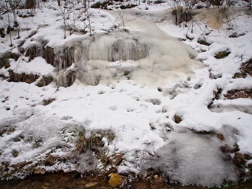
I went past the Ice Wall to see if there was any ice forming. This area is wet with a lot of water seepage so the ice is forming.

in January...


The raccoon have taken over the 'cave' area. I could smell the scat from above it.


Then it was back out onto the cropland. I hiked through the corn stubble and cut across to our property line.
I hustled down the steep hillside to the creek. I checked my time and I wasn't far off schedule. I'd told Rich that I'd take about an hour and a half. I had 20 minutes to spare.
I marched an slid down the hillside and back to the creek. I grabbed the knotted rope we call "the elevator" and used it for balance while climbing up the steep bank.

The arrow points to the rope I use to go up the bank.

I made it home with two minutes to spare.
I grabbed some dry clothes [I'd sweat through my shirt and sweatshirt] and helped Rich finish the stock tanks.
How did I feel afterward? I thought I'd ache all over.
I did not.
I thought I'd feel it today.
I do not.
However, I did sleep like a baby last night. 8 full hours of sound sleep. After 9 years of odd shift work and no sleep pattern, I am finally feeling a bit more normal. I feel like leaving that job gave me back years of life.
I'm already plotting my next hike.
Sure wish there was that much to see (Mean appreciate) when in the city.
ReplyDeleteBlogmomrocks2 ~ I am lucky to live in an area with a lot of visual wonders.
ReplyDelete