Showing posts with label ice formations. Show all posts

Monday, January 13, 2025

Another spot I've followed ....

...through the years.

I went hiking on PeeWee's. The large tract of land next 'door' on Saturday. I wanted to check out one of the first ice formations I discovered.

The hike to there is done through two valleys and a ridge and across a large field that used to be pasture for cattle. It is now cropland that is rented out.

The hike to this spot is 1.5 miles. To get an idea of how remote this spot is...
well there are no houses or roads anywhere nearby or within sight. 

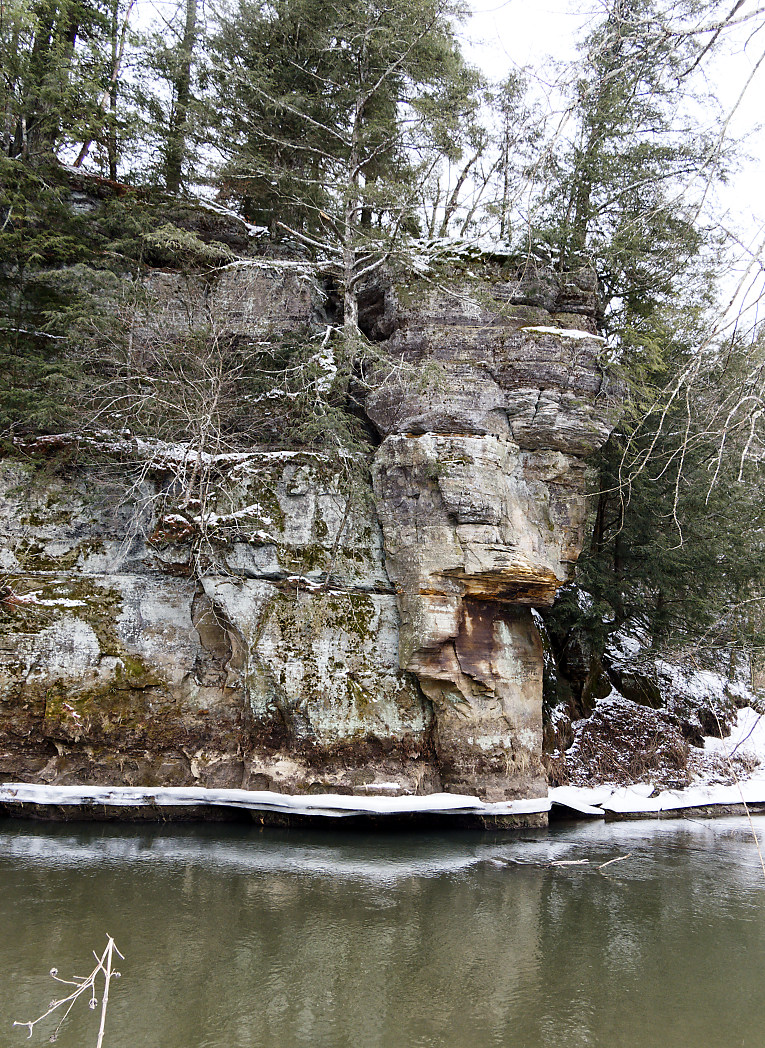
The guys that inherited this land call the area below this dry run... The Lost Valley. 
The valley is very remote. It is steep and narrow. More on that in another post.

This is another favorite spot of mine. It starts at the top of the ridge and drops about 150 or so feet down into the Lost Valley.


I've followed this spot over the years ever since I've discovered it. 

Some years this part of the dry run gets an ice sheet over the opening of the rock shelter. Racoons, love to use the 'cave' as shelter in the winter.

This black and white shot is from 2019 when I was brave enough to take a rope and climb down into the gully.


Close up to the jaws of ice...


2011 another time I climbed down into the gully. I couldn't climb out of the dry run so I had to scramble over boulders and ice to follow the dry run to where it emptied into the stream below.
[The reason I now take a rope if I am going over the side.]


And when spring arrives...the ice loses its beauty.

I shot this shot last year leaning against the same tree as I did for the second photo.


This next shot was taken in November of 2001.

I climbed up the dry run from the creek in the valley wondering where it went. I had a Pentax K1000 with a broken light meter but I was able to guess at the exposure.


This shot may have been the very beginning of my love for Ice Caves, Falls, and Ice Formations.

If we get moisture in the form of snow and rain, this may develop into a more spectacular ice formation by late February or early March. 

The hike took me to the west side of this ridge and a newer ice falls. During the huge and devastating flash floods of 2016 and 2018, the small dry run turned into a huge ravine.

To my utter amazement and delight, this too had ice formations. I'll have to check out a safe way to get down into the area, but color me happy to find more ice.


The edges of this dry run in the spring have the most amazing spring flowers. I also visit this area in the spring to see all the Hepatica, Trillium, Skunk Cabbage, Spring Beauties, and more.


It was a long and satisfying hike. The ice falls/caves are doing well but need more moisture!

Monday, February 13, 2023

Drifting in the Driftless

 I thought it was cool to come up with that: Drifting in the Driftless.

Because that is exactly what we did together. I had a goal in mind, but I abandoned that goal and just decided to drift back and forth like the tiny stream that meandered through this narrow valley. 

The stream is not indicated on the map so it must come from various springs along the way. The valley is no more than 50 yards wide at its widest spot. The north facing hillside is steep with many 'dry' runs and rock shelters.
The south facing side is nothing but bluffs dotted with caves that I did not explore [this time].

Charlie and I followed the valley from the west end to the east end where it ended at the new highway that was built in the 1970's. 

Photo of the Kickapoo River
taken with the Infrared Camera.


The ice 'slide' in IR.


Rock Shelter with ice, IR.


I made a series of very short video clips and stuck them together to form a little view of what it was like. The video of course doesn't do it justice but perhaps one can get the sense of just how narrow and secluded this area was. 

I'm keeping the location to myself as I am pretty sure there are some rare plant species that thrive in this micro climate that is so unusual. 


So in the first part of the video you will see a familiar spot of the Kickapoo River. It was frozen over but the grinding noise was the ice moving and trying to make passage through the river. It unnerved Charlie enough so he started to whine.

The rest is with no sound because I don't think anyone would enjoy listening to the mic noises.

The video is 1:44 seconds. To see and understand just how narrow and wild looking this place was...I had to do it as clips.

Hope it is worth your time.


I was going to go back today but needed and eyeball rest. I'll be going back on Wednesday to visit the hogback above the caves. At least that is the plan.

Happy Drifting

Peregrinating

and Maundering about....


Tuesday, January 24, 2023

The Other side...

Last week I hiked along the east side of the river bluffs in a section of the Kickapoo Valley Reserve. 

View of last week's hike from the other side 
of the river.


I wanted to see just how far down the river I could get before I ran out of shoreline. Charlie and I made it about 3/4 of a mile and it was there that I noticed the large chunk of bluff that had broken away from the original bluff.

Now this could have happened a thousand years ago or whenever. I'm not a geologist, so I haven't a clue.
I wanted to compare it to the term 'calving' like when a large chunk of ice comes off a glacier.
I decided to walk along the western bank which has no bluffs, however that is where all the logs, trees, and debris from floods end up. 
It is a definite maze of downed trees, logs, roots, and weeds.

I didn't wear snowshoes so I had to fight the deep snow. Wearing the snowshoes would have made the climbing roots and logs much more complicated. 

I saw coyote tracks, I saw a beaver in the partially frozen pond to the south, but what really surprised me were some odd tracks on top of the snow.
It looked like something had been sliding in and out of the river.


It finally dawned on me when I saw a hole in the bank with tracks in and out, that perhaps the river had otters?
Oh Boy!
I studied the terrain directly across from the 'den' and thought it would be fun to come back and sit quietly on the bank or bluff above the supposed den and watch.
I've never seen a wild otter.

I did a LOT of climbing over banks and logs. Here is a photo of my leg in the side of an icy bank. [No, I would not have ended up in the river if I'd fallen! I was at least 10 feet from the water. I play it safe when alone.]


Recall the hole in the rock I am searching for? Well last week I stopped at the orange arrow as there was no shore left to walk on.


Another view of the flat rock.


There is the hole, the tunnel, the cave...whatever you want to call it. 


Getting there by land is going to involve some research.


The area above the rock bluffs and the river can be hiked but it would be an experience for sure. 

Below is a topo map. The orange arrow points to the rock with a hole in it and on each side of that spot, the river is right up against the bluff.

The black triangles are camping spots and the dotted lines are trails. The solid black lines are roads. 
I may have figured out a way from one of the campsites or come in from the road through the brush and just find my way.


If nothing else, I'll first explore it coming in from the road which would involve less climbing and be able to look out from the top of those bluffs.

The trail next to the river [blue line] is about 160 feet below the top of the bluffs according to their calculations.

This is near that bluff and some straight on shots of the rock formations and ice.
I doubt too many folks see this as it is a chore to get too, but not too bad in the winter time.


My hike ended up being about 4 miles. Half of it was rough hiking and half was on trails. Getting off the trail and walking along the river was really quite beautiful.

I have more bluffs to explore before spring comes....


Friday, January 20, 2023

Exploring


Mr. Charlie and I went Exploring last week on Saturday. We left early and got to the Reserve before most people are getting up and about. I like it that way especially when I take my UnCharted Trails.

Actually, they are trails from long ago and are no longer included on the maps. They are perfectly fine for walking though and equine traffic would have damaged the sensitive plants that are in certain areas of the reserve.

I decided to walk along the base of some bluffs alongside the river. I'd gone this way in the late fall and thought it would be nice to see if any ice was forming along the NW facing bluffs.

Charlie and I saw some Coyote Hunters getting a lecture on something from the game warden otherwise, we saw no one. We turned off the main trail and found our way to the bluffs.

The bluffs sometimes have some incredible ice formations on them and in other spots they have some of the most interesting looking roots and fern growth.

This tree stops me in my tracks every time I walk by it. The twisted roots cling to the bluff and variations of cooler weather ferns hang out with it. Behind it on the rock are various colors of lichen.

To me, it is a wonder.


The edges of some of the bluff tops did have ice forming on them.


This one below is spectacular depending on the year. In past years I've observed these bluffs from the other side of the river. I wanted to see it up close. As melts and freezes continue, it becomes a river of frozen little waterfalls. 


More ice shot with the infrared camera:


When I got past these bluffs, I came to a spot where I'd have to climb rock or go up a valley to head further north. I decided to just end the hike here.
I peered at the huge chunk of rock upstream and noticed it had a gap in it that cannot be seen from the other side of the river.


If I am correct in my thinking, this is the same rock seen from the other in 2017.
And...I think I know how to get to it. Looking at the topo map, it will involve some rather difficult hiking.


That is one of my goals this winter or spring is to check out that 'hole'. It may not be possible, but how will I know unless I try?

The view from bridge 16 with my infrared camera. I was shooting for the black and white effect and was pleased.


I'll be returning to this bridge in the next few days to check out some more ice features and study that bluff from the west side of the river.


Monday, January 09, 2023

Annual hike Gone to the Dogs....

I met Jason and his dog Piper last year on New Year's Eve. We hiked together for the first time during the Kickapoo Winter Festival in 2022. We hiked together a couple of time sense then. Saturday we met up again to hike at the Weister Creek ice cave trail.

Jason had adopted Felix just weeks ago. There is a lot of unknown about Felix as he is an older dog who supposedly lived on the streets. 

Felix is in the red coat. Charlie is trying to help Jason do something or get in his car.


Here Piper is running back towards us on the trail. Piper wears a coat and also has Paw Balm on her feet to help protect her feet.

She seems to have boundless energy.


Both of Jason's dogs are adopted rescues and he absolutely adores his dogs. Charlie adores Jason too because he has the greatest dog treats.

Jason explained that he wanted to see how Felix would do on a hike that was a bit longer than 30 minutes. He planned on taking his dogs with him to Superior next month to visit the Ice Caves along the lake.

Charlie didn't wear his coat, I'm still trying to find something that will allow his tiny legs free movement when negotiating deeper snow and jumping logs. However, the weather didn't bother him one bit.

His orange reflective vest is great for visibility as long as we are on a groomed trail.

Photo by Jason:


Piper, chillin' out:


We got to the Ice Caves fairly quickly.

Piper lead the way and then waited for us.

Ahhhh hah!

We can see who the dogs prefer!


Felix inside the ice cave doing his own thing.


We spent a long time exploring the ice formations and Felix started to get a bit grumpy and began to shake. We figured he was cold and decided to head off the bluff we were on.

By the time we got down into the valley, Felix was himself again and walked sedately behind me or Jason. Charlie often walked shoulder to shoulder with Felix. [Hey! A new friend for Charlie that doesn't try to roll him over like a ball!]


Piper kept bounding around us and trying to get Charlie to play. Charlie decided that Felix was more his speed. All was good in the doggy hiking world.

We met up with two large groups of people. Felix just walked by them and ignored them with no more than a sniff. Piper sat out of their reach and waited for them to pass. She is good with one or two people, but shy of crowds.

I had leashed up Charlie because he is a greeter and adores humans of all kinds. They asked if they could pet Charlie and I said sure. I let him off leash and he did his Charlie thing. He squeaked and grunted with pleasure, his tail doing wild wags.

One lady asked how did Charlie get through all this snow? Charlie showed off by jumping a log and diving through the snow to circle around her with glee.

My answer: He Loves Snow!

We got to the end of the ice formations near where the old Beaver Dam used to be. Jason climbed out on a boulder next the the very cold and very swift Weister Creek where he wanted his photo taken.


It was pretty funny that Charlie whined and fussed all the time Jason was up there. I kept him with me as I am sure the little stinker wanted to try and jump over the water to get out there.

Our hike back was rather quiet and unexciting. We talked about meeting up again this winter for another outing. I think I'll take him to an off the map place to see some bluffs and ice.

Hopefully, it will all work out. And...Felix did fine on a 2 hour hike! We didn't hike fast but kept it to his pace.

Charlie was exhausted from his outing.

Another good hike in the books for the start of 2023!


Tuesday, January 03, 2023

I like ice

Not Ice Cubes, or Ice Storms, or Icy roads but natural ice formations. 

I like ice caves or actually ice formations. I like those rock shelters that have water seeping over and through them. In the winter they form exotic and beautiful ice curtains. The colors of the ice can be stunning depending on what the seepage picks up. I've seen hues of greens, blues, and yellows.

It all has to do with absorption of light and reflection of light. But I just admire it for what it is.


I'd planned on this hike for over a week so I packed my things and set off.

It is one of the winter attractions at the Kickapoo Valley Reserve. Getting to this valley is described in the brochure as "Trails into and around the ice flows are steep, slippery, and strenuous travel. Walkers are are advised to use caution as the trails are strenuous back country winter hiking."

This is true. The trails are there and sometimes even easy to follow late in the year by all the frozen foot prints in the snow. The trails are not maintained and sometimes marked with blue strips of ribbon on trees.

I hadn't done a proper exploration of the Valley of Ice last year, just a hurried walk through when I met my Geologist friend Jason and his dog Piper.

This time I wanted to take my time and explore.

So I did. I found the first ice cave after taking the trail from the maintenance building along the snowmobile trail. The 40+ degree weather had melted the packed snow into ice and the light skiff of snow and sleet we had the night before made that trail just plain treacherous. I trudged through the snow on the side of the packed trail. 

The first cave wasn't too impressive and many more large trees have fallen over the past year. Climbing through the mess wasn't my what I intended to do first thing so I followed a run off along the valley floor. 

In a way it was a happy accident because it took me far out off the trails and to where I wanted to explore last spring. 

Charlie and I crossed the backwater marsh on the eastern side of the river and gazed across towards the Valley of Ice on March 11th in the blog titled Time Out.

I ended up where the arrow is in the next photo.


I sort of rejoiced in the discovery and then turned towards the steep hillside behind me and get back to the trail.

According to the contour map of the area, I had to climb 100 feet up from the valley floor back to find the trail.

I did. And I enjoyed every bit of it. At times I sat on an old pine tree's roots and stared down into the valley and the ice covered river. 
I was feeling every second of being alive. 

I took off my coat when I reached the trail on top and carried it as I hiked along the trail back towards where the ice caves were. I did a face palm as soon as I realized that the trail would take me around the top of all these valleys and that I'd be going at least an extra mile. I secretly was glad no one else had gone with me. However, doing all of the trails last year was a real bonus. As I immediately knew where I was and how far I had to go.


In good time I found the right valley and the first of the Ice Caves. I made my way down into the run off below the cave.


It looks as though you can walk right on into it. Well, it takes some scrambling and some grit. Here is the view from where I was sitting inside on the left part of the cave.


I scrambled around to the other side. Having good insulated and water resistant pants is a good thing here. I sat inside for quite a few minutes and listened to the water dripping. It was peaceful.


View of the Ice Curtain across the front from the inside.


As the noon whistle went off in LaFarge, I was halfway back to the parking area. 

I passed up a father and son who asked me about the ice and then a couple with their dogs. A pit bull and a mini Doxxie. It seemed that a  few people were taking advantage of a nice sunny Holiday to get out and walk.

When I got to the parking area I had to laugh. It seems Subarus like to park near each other. 


I can't wait to go back and explore some more.

Valley of the Ice