Map My Hike says this hike had 435 feet of elevation in it. Hmmm.
I'm not sure how these apps that follow you figure that out. But I do know that from where I parked to the top of the narrow back ridge was a climb of 300 feet. That is according to the topo map from KVR.
I didn't do a 'close up' of the map because I wanted those read the drivel I write to see what the terrain is like where I walk.
This is the terrain of the 'driftless' region of Wisconsin. The bumps are hills, the shaded parts are slopes. The terrain map helps visualize what it is like where I live. Nothing is level, it is up or down!
The trail is pretty straightforward to the top.
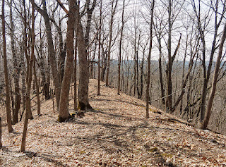
It is either an old logging road or farm road, it leads to an open area that has been logged and left. Briers and Prickly Ash grow so thick in its place that I doubt anyone or anything would want to walk the open area.
The trail goes around this mess and stays on the sides of the ridge in a mostly old oak forest. Finding the trail in the summer is nearly impossible as Charlie and I found out last year.
We found the top of the ridge easily.
We walked out to the point to see if there was much of a view.
I could look south and see Highway 131 ...
and look north and see the Highway leading to Rockton.
In the summer these limited views are impossible. But, I satisfied my curiosity and decided to finish the trail.
Some places were well marked, and others markers were a spot of yellow ribbon tied to a branch or a tree.
There is no chance of really getting lost as long as you have looked at the map and know to travel around the top of the oddly shaped ridge.
There is a steep drop off if you do get off the ridge.
There is a steep drop off if you do get off the ridge.
It doesn't seem at first that Jug Creek has a lot to offer in the wow factor. However, the old oak stands and maple woods provide a lot of shade and it is nice and cool on a hot summer day on the narrow ridge.
In the spring the forest floor will be covered in Spring Beauties and Pinks.
In the spring the forest floor will be covered in Spring Beauties and Pinks.
According to the pamphlet that is available at the Visitors Center, this trail is still under reconstruction. Clearing sections of this trail is not going to be an easy task.
I'd actually like to come back in the winter and snowshoe around the ridge.
Section 44 done.


You chose a perfect hiking weather day and got another challenge section done. Any idea approx. how many completed the KVR challenge last year? Just curious.
ReplyDeleteI enjoy "see through trees" season, especially no bugs. Although we have already found some ticks on the dogs. Colors are a bit blah, but the viewing further makes it interesting. Glad you & Charlie enjoyed a nice climb-n-hike!!
I got my new no-seeum head nets just a few days ago in prep for bug season. I don't mind wearing the net, it really helps.
Delete6 people completed the challenge last year. I was the 3rd person who turned in my sheets.
The colors were pretty bleh, but the mosses were pretty bright and cute so it wasn't a loss.
I really enjoy your hikes. I lived on our family farm in southern Iowa where the the 240 acres was just like your terrain. Their was not a flat area anywhere. We had half timber on the hills and one side area of original prairie that was too rough to ever farm. The creek was such a joy for me to explore. Spring was such a great time to see new life.
ReplyDeleteI can imagine! I sure that would have been fun growing up there with a creek nearby.
DeleteI know I enjoy our little creek.
You could write a book about the trails! Happy Easter! I didn't see any snow in your photos so maybe you have Spring! :)
ReplyDeleteI'm not a very eloquent writer, I need more practice. However, I'd love to write about the trails. I think the more I hike them, the more interesting they become.
DeleteYou don't live in the rolling hills part of Wisconsin!
ReplyDeleteNo I don't! They really are hills and valleys. Most valleys have difficulty with cell phone reception.
Delete